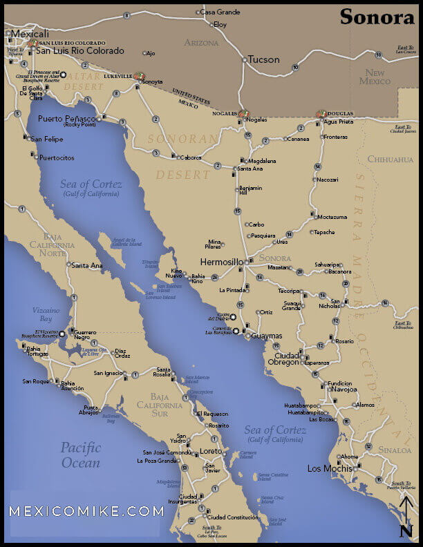
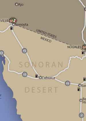
This northwestern state of Mexico is filled with stunning scenic attractions. As the country’s second-largest state, Sonora would be difficult to navigate without using a map. There are several border crossings between the U.S. and Mexico in Sonora such as Nogales and Agua Prieta. Many travelers visit Sonora simply to enjoy the festive border towns; however, travelers can also use the map to help them reach the capital city of Hermosilla or any of the state’s natural attractions like the El Pinacate Biosphere Reserve or the beaches of Puerto Penasco and San Carlos on the Sea of Cortez.
Tucson, Arizona to Hermosillo, Sonora Driving Directions
The four-and-a-half-hour drive from Tucson to Hermosillo is quite easy to navigate using the Sonora map. Heading east on Broadway Boulevard toward S. Country Club Road, make a left on S. Kino Parkway. Head onto the I-10 W. ramp toward Phoenix and merge onto I-10. Merge onto I-19 S toward Nogales taking exit 260. Make a slight left on N. Sonoita Avenue. Go right on W. Crawford Street and right again on N. Grand Avenue into Mexico. Continue traveling on Adolfo Lopez Mateos/Heroica de Nogales-Imuris, but then continue to follow Heroica de Nogales-Imuris by turning left, then right, and then left again onto this street. Head onto Imuris-Magdalena de Kino and then Magdalena de Kino-Santa Anna. Head onto Santa Anna-Hermosilla. Make a right on Boulevard Ignacio Soto and then left on Francisco Eusebio Kino. Make a left on Juan Jose Rios. Head onto Hermosilla-Santa Anna/Santa Anna-Hermosilla and follow Santa Anna-Hermosilla going through one roundabout. Make a right on Gaston Madrid and then right on Cuernavaca. Make a right on De Las Americas and head into the city.
Yuma, Arizona to Puerto Penasco Driving Directions
As the nearest beach for Arizonans, this route is quite popular. Using the Sonora map, travel north toward W. 19th Street and make a left on W. 19th Street. Make a left on S Avenue A. Make a right on W. 24th Street. Go left on US-95 S/S Avenue B and continue following this road into Mexico. Take a slight right on Route 1 and then turn left on Avenue Obregon. Head onto San Luis Rio Colorado-Sonoyta / Sonoyta-San Luis Rio Colorado / Mexico 2. Veer right onto Puerto Penasco-Sonoyta/Sonoyta-Puerto Penasco/Mexico 8 and continue following for about 56 miles. Continue on this road until reaching Simon Morua and make a left. Make a right on Juan de la Barrera and head into town. Once in Puerto Penasco, reference the Rocky Point Map, or for street-level detail the Puerto Penasco Street Map!
Navigating the Outlying Areas
While this Sonora map will help travelers find locations within the large towns and cities of Sonora, it is essential for navigating the outlying areas. Sonora is filled with rough desert terrain so drivers should be sure to have water and a cell phone in the event of a breakdown. The map will help guide travelers to fishing villages on the Sea of Cortez, archaeological sites scattered throughout the states, and, of course, many scenic regions. For navigating the remote locations of Sonora, be sure to have the map at the ready!