Tijuana to Valle de Guadalupe Driving Directions
Click on the Valle de Guadalupe Map and follow these instructions. The drive to Guadalupe Valley takes about an hour and a half. Starting out from Tijuana, Travel northeast on Canon Zacatecas. Turn right on Enrique Gonzalez and then left on Manuel Acuna. Then, turn right on Brasil and then left on Fundadores. Veer onto Negrete and then make a right on Juan Sarabia. Merge onto Decima and take one roundabout. Make a right on Via Rapida Pte and then the left to continue on Via Rapida Pte. Head to the exit for Tecate/Mexico 2D and veer onto Bulevar Lazaro Cardenas. Merge onto the Boulevard Alberto Limon Padilla and stay left at the fork. Continue to follow the signs for Mexico 2D / Tecate Cuota and then veer toward Tijuana-Tecate/Mexico 2D. Take the exit Boulevard Universidad, Mexico 3 toward Ensenada and remain following Mexico 3 into Guadalupe.
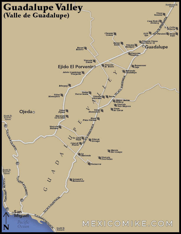
Mexicali to Valle de Guadalupe Driving Directions
This nearly three-hour trek from Mexicali is a great showcase of the Baja landscape. Start out traveling south on Guillermo Prieto heading toward P. Ortiz Rubio. Make a right at Avenue Sebastian Lerdo de Tejada. Go left on Calle E and then make a slight right on Comandante Alfonso Esquer. Upon reaching the roundabout, use the third exit and merge onto Boulevard Adolfo Lopez Mateos. Make a right into Calle del Hospital and right again on Calz Independencia. Take a left onto Calz de los Presidentes and veer right at Eje Central. Then, take a right on Boulevard Lazaro Cardenas. At the roundabout, take Calz Ciudad del Sol and head onto Calz Coronel Esteban Cantu. Continue to Mexicali-Tecate/Mexico 2 and continue to go right to remain on this track. Merge onto Mexico 2D taking the ramp to Tijuana. Take Mexico 3 toward Ensenada. Head left on Boulevard Universidad. Continue on Tecate-Ensenada/Mexico 3 to Guadalupe. The map can help you navigate the Guadalupe region.
Traveling through Baja California
Since many stretches of this state are remote, it’s always a good idea to have the map on hand along with plenty of water. In the event of a breakdown, a cell phone is also a good idea. The map of Baja California will also include other sites that travelers may want to visit on their route to Valle de Guadalupe. Travelers who visit Tecate, as well as Ensenada, frequently make the trek to these wine lands too. Valle de Guadalupe is far more remote than the vineyards of Napa and, perhaps, also more pristine. Yet their remoteness means that it can be difficult to navigate the region. Use the map, therefore, to get around this part of Baja California. There are many lovely sites and attractions to behold and the wine, of course, makes this journey well worth the effort!
Remember that drinking and driving in Mexico is illegal so…designate a driver!
Wine Country Baja California
The Valle de Guadalupe, which is also referred to as the “Wine Country in Baja” is a great place to visit. The restaurants and hotels are high end, the food is exceptional you wont be disapointed.