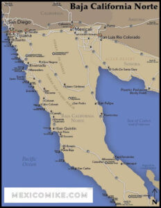
Whether you’re already in Rocky Point (or Puerto Peñasco) or you’re looking for directions here, these Puerto Peñasco maps will help you navigate this magical Mexican city on the Sea of Cortez. One of northern Mexico’s most popular travel destinations, the city of Puerto Penasco, or Rocky Point as it is known in the U.S., is within easy driving distance from the border, as travelers will see by consulting the Puerto Penasco map. Located in the Mexican state of Sonora, the city of Puerto Penasco is famous for its beaches and myriad attractions. For help with driving directions, check out the Puerto Penasco map, which can also help travelers locate various sections of the city and the region, main thoroughfares and highways, and even natural or historical landmarks.


Phoenix to Puerto Peñasco Driving Directions
In a little less than four hours, travelers from the hot valley city of Phoenix can land on the gorgeous beaches of Rocky Point and discover why so many vacationers fall in the love with the Sea of Cortez and Mexico’s sunny hospitality. Using the Rocky Point map, locate Phoenix and see that it’s nearly a straight trip south, veering slightly to the west. Drivers should head west on I-10 out of Phoenix to State Route 85 and go south. Remain on SR 85 through Gila Bend and Ajo. As a large town on the journey, Ajo is a great stopping point for supplies or a break in the drive. Continue on SR 85 through Organ Pipe National Monument down to Lukeville, where you’ll cross into Sonoyta, Mexico. You’ll stay on the main road for just under two miles. When you hit the fork in the road, be sure to veer right and follow the signs for Puerto Penasco to Mexico Highway 8. Remain on Highway 8 until you hit the town. Once there, you can use the Rocky Point map to help guide you to various areas of the city or follow the city signs leading to specific resorts.
San Diego, California to Rocky Point Driving Directions
Most people driving from Arizona head for Yuma, Arizona ,which is an important junction for various highways. When departing from San Diego, take I-8 East all the way to Yuma. You can see from the Rocky Point map that it’s nearly a straight shot east. From Yuma, continue on I-8 East through Gila Bend; then, take SR 85 South to the border at Lukeville. Cross into Sonoyta, Mexico ,in the state of Sonora ,and drive nearly two miles to the fork. Veer right and follow the signs for Puerto Penasco to Mexico Highway 8. It’s important to stay on Mexico Highway 8 all the way to the city of Rocky Point. Upon reaching the city, there will be signs highlighting various exits for specific resorts ,and travelers can also consult the Rocky Point map for locating preferred regions of the city.
Puerto Peñasco Maps to Get around the City
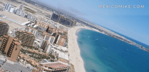
The map will allow visitors to locate beaches as well as RV parks and other sites of Rocky Point. The city boasts fine beaches, golf, off-roading, sport fishing, whale watching, and other area attractions that are popular with tourists. Camping, golf, whale watching, and shopping—are just a few favorite pastimes for visitors to Rocky Point. Use the map to find major streets and thoroughfares to help you navigate the city and find all the addresses on your itinerary more easily.
Always remember ,as you drive in Rocky Point, you are in Mexico! Even if you have super insurance in the US that covers damage to your car, they are not able to provide 3rd party damage in Mexico. Without Mexican liability insurance, you could be in trouble. See for yourself by getting a quick quote for Mexican Insurance by clicking here.