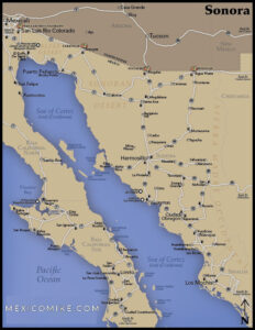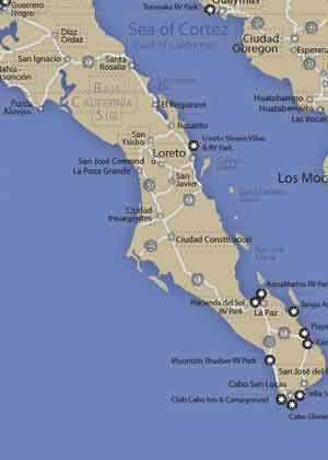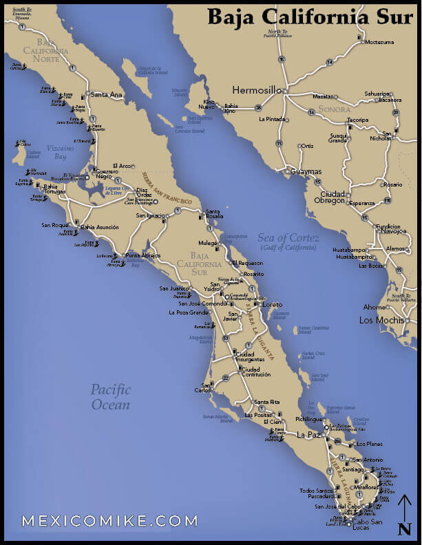
The Map of Baja California Sur shows the mountains, deserts, the Ocean, and the Sea. Traversing the beautiful wild of Baja California Sur isn’t that tricky without a map. But maybe it can help you find the best places to visit. Use the map and the following directions to help you navigate this dynamic state!
Mountains, deserts, the Ocean, the Sea—traversing the beautiful wild of Baja South can be tricky indeed without a map. Moreover, using the Baja California Sur map will help travelers locate the best places to visit, the most revered scenic attractions, and the most popular cultural attractions too. Use the map and the following directions to help you navigate this dynamic state!
Ensenada to Cabo San Lucas Driving Directions
This 750-mile journey is roughly a straight shot from north to south with a bit of zigzagging here and there. A wonderfully scenic trip, this stretch is also easy enough to traverse. Plan on a seventeen-hour drive to get from here to there. When exiting Ensenada, drivers should go north on Boulevard Reforma and veer left at Avenue Benito Juarez. Go right on Boulevard Reforma and on to Ejercito Nacional. Drive toward Ensenada-Lazaro, making a series of rights as directed to turn onto Ensenada-Lazaro; this stretch will also be referred to as Carr Federal 1, and drivers will remain on it for about fifty miles.
Make a left on Guerrero-Negro-Lazaro-Cardenas and continue on Carr Federal 1 for roughly 550 miles. Then, turn left on Loreto-Ciudad and continue to follow Carr Federal 1. Turn right on Ciudad Constitucion-Lapaz. Turn right onto Lapaz-San Jose del Cabo and then take the ramp toward La Paz Todos Los Santos / Mexico 19 and follow Mexico 19 onto Boulevard Hidalgo. Veer right onto Calle Cabo San Lucas and turn left onto this road. Drive into town and enjoy!
San Felipe to La Paz Driving Directions
This 15-hour journey takes drivers through some exciting and beautiful terrain. Using the map of Mexico, travel southwest on Bermejo. Turn left on Isla de Cedros. Make a left at Avenue Mar Caribe Nte. Head onto Camino del Sur and travel toward A Puertecitos. Turn left on Guerrero-Negro-Lazaro-Cardenas and then make a left on Loreto-Ciudad-Constitucion, continuing to follow Carr Federal 1. Travel onto Gral Agustin Olachea Aviles. Continue onto Isabel La Catolica and into beautiful La Paz.
Map of Baja California Sur: Sites of the Journey
As you can tell from the Map of Baja Califonia Sur, both journeys are considerably lengthy by car. It makes sense to break up the trip by visiting various places and villages. By using the Baja map, drivers can adjust their journey to visit national reserves, ranches, or even historical and archaeological places of interest. Moreover, use the map to make stops at seaside towns to enjoy meals while making the journey. The route will help you locate the main thoroughfares so that finding these destinations and then returning to the adventure at hand will be no problem.
When traveling through the Map of Baja California Sur, there are many long stretches with little insight. The state is still remote in many areas, so keep the map safe as it may come in handy in the event of a detour. Also, keep water in the car. A cell phone is super important, make sure you know how to dial in Mexico and that you notify your carrier for international. Please make sure to check these links before you follow this Map of Baja South: