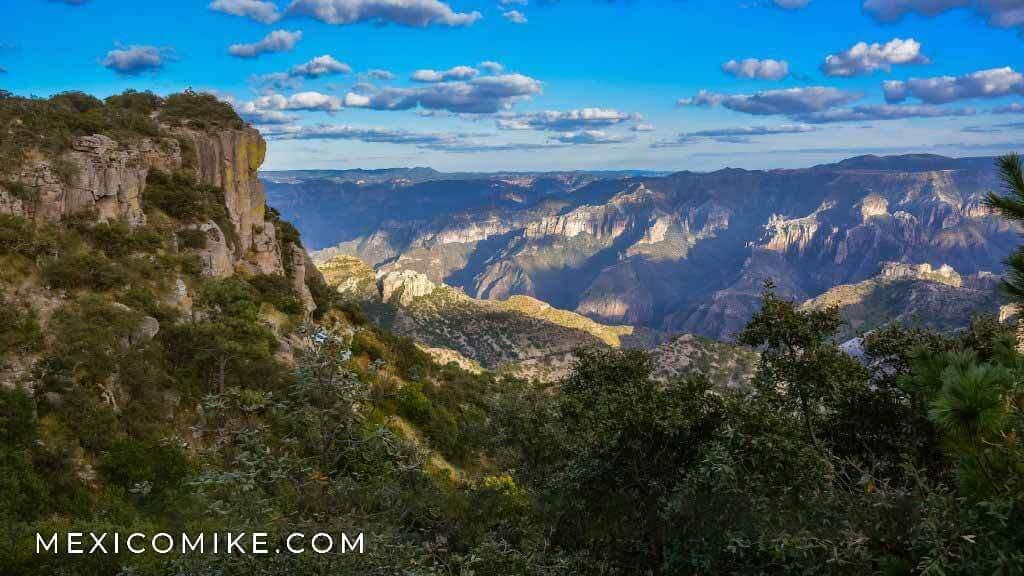
Driving the Copper Canyon is on almost everyone’s Bucket List – even those who aren’t Mexico aficionados. Motorcyclists consider it the greatest ride in Mexico. RV’ers are seduced by photos of caravans with RV’s on flatcars while the owners view the scenery and sip Margaritas in the bar car. Spiritually-minded people find meditating on the edge of a thousand-foot cliff drop most fulfilling. Though the area economy revolves around lumber which competes with natural beauty and tourism, the two coexist. The towns are small and do not have that feeling of being hustled or of being a walking dollar sign that you get in some other tourist destinations. Perhaps it is the spirit of the Tarahumara, the natives who live here. They are shy, quiet and have a live and let live attitude. Most writers compare it to the Grand Canyon in Arizona because the Barranca del Cobre is longer and deeper. That’s where the comparison ends. Each is a unique place and each should be appreciated for what it is. One pleasant difference is that even on the most tourist-full day, you will have more elbow room than in AZ. Walk the boardwalk streets and soak in the feeling that you’ve entered a time warp.

The Train
To visit the Barrancas del Cobra, or Copper Canyon by Train is the best way to see this natural wonder. The Sierra Tarahumara of Chihuahua, where you’ll see one of the largest and deepest canyons in the world, is known as Barrancas del Cobre (Copper Canyon) and it’s one of Mexico’s most awe-inspiring regions.
To visit this area of Raramuri Indian culture, it is recommended that you climb aboard the Chihuahua-Pacifico train (Copper Canyon Train), commonly referred to as CHEPE. The route begins in Ojinaga and the train makes stops in the cities of Chihuahua and Chauhtemoc, where you’ll see various Mennonite colonies.
The trail continues along with the Sierra de Creel, a mountain range that lies 2,400 meters (7,920 feet) above sea level. It then runs past the Divisadero station and descends through canyons, tunnels, and ravines that border the edges of the majestic Copper Canyon and the Tararecua and Urique canyons. Along the route, the trail crosses 37 bridges and goes through 86 tunnels before arriving at Los Mochis, in the state of Sinaloa.
The train was the dream of Albert Kinsey Owen who established a Utopian colony in Topolobampo, SIN. In 1885. Owen’s practical dream to help finance the colony, called Pacific City, was to build a railroad from Galveston, TX to Topolobampo. Alas, Owen was something of a dictator (not a good thing for a Utopian Socialist) and most of the colonists called it quits by 1893. The railroad was started and stopped several times up to the Mexican Revolution and completed by the Mexican government in 1961.
Because most articles about the Copper Canyon are written by non-drivers, you might think the train is the only way to see this magnificent wild area. Or, if you are an RV’er, you may have been seduced by images of rigs tied onto flatcars while the owners are sipping martinis in the club car.
Having driven much of the canyon and taken the train several times, I offer another opinion. As drivers, we can have the best of both worlds.

You can drive your car or rig to Creel, safely leave it there and catch the train. Conversely, if you are on the Pacific Coast, you can drive to El Fuerte and leave your vehicle safely at a hotel.
El Chepe – Senior and Junior
The train, El Chepe, is famous for its meandering route, doubling back on itself like a snake eating its tail. It makes the once impossible trip from Chihuahua, Chihuahua to Los Mochis, Sinaloa a nine to twelve-hour surprisingly smooth ride. An engineering marvel, grades are gradual and none exceed 2,5%. The whole trip is 405 Miles, 653 KM.
There are now two El Chepes – Chepe Express (luxury) and Chepe Regional (standard and economy). The Express runs only from Creel to Los Mochis and vice-versa. It has a short roundtrip from Creel to Divisadero on Saturdays. Unlike the Regional, which stops at several whistlestop towns on the way, it graces only Creel, Divisadero, Bahuichivo, El Fuerte and Los Mochis with its lumbering presence.
Although travel writers uniformly scribble that the best way to experience the Canyon is to take the train from El Fuerte (an hour or so up the trail from Los Mochis, SIN.). Having ridden the train from both ends, I can see their point, though it is not as relevant to those of us who combine driving and training.
The flatland from Los Mochis, past El Fuerte to the Chihuahua state line is boring. An hour or so before Bahuichivo, it gets interesting.
At the end of March, the Chepe Regional will no longer run as a tourist train. It will be converted to a commuter train for residents of the area, just like the Express train. Whether a tourist will be able to buy a ticket on the Regional in the future is up in the air. Go to the official website before getting your hopes up. The two trains run in opposite directions on opposing days (except Saturdays), so a little planning is a necessity.
At the moment, due to Covid 19, the Express train is not running. The Regional is, but only for locals. When this will be over is anyone’s guess.
For schedules and to purchase tickets, see https://www.chepe.mx/.

Driving the Copper Canyon – Creel
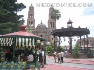
Creel is the logical start to exploring the Copper Canyon by vehicle. It is easy to get to from Chihuahua. You will go to this capital city of the state by the same name whether you come from the north (El Paso, TX or Columbus, NM), or the south (Durango, Torreon). The drive is a mix of four-lane near the city and two-lane in the country.
Here is a short road log from Cd. Cuauhtémoc.
- 68.0 Come to Cd. Cuauhtémoc.
- Cd. Cuauhtémoc is a dusty, busy burg. Traffic sucks but there is only one way in and one way out of town. Eat here because you are a distance from a decent meal.
- 29 miles more and you come to La Junta. There is GAS here. Fill up. Turn LEFT for Creel. Road is 2-lane and moderately curvy, but RV’s have been driving it for decades.
- 43 Come to village of San Juanito.
- 54 Through Bocoyna and then Sisoguichi. There are waterfalls here.
- 58 Come to Creel. The town is over the RR Tracks to your left. For RV’s keep driving until you see either the road from town crossing the tracks or a GAS on left. There is a more RV friendly entrance there.
Nothing is hard to find in Creel. Most hotels are on or 1 block off, Ave. Lopez Mateos.
Hotel Villa Mexicana and RV Park
The only RV park in the Canyon is in Creel. 73 total RV sites, can accommodate any size RV, and full hookups. U.S. Tel: 1-888-610 2095 I called them and they are still open both as a hotel and trailer park for the 2020-2021 season. Hotel prices UPPER. Very nice.
The Lodge, Best Western at Creel Hotel & Spa
This is one of my favorite hotels in Mexico. Built “frontier-style” with wooden floors, walkways, and walls it is surprisingly quiet. The restaurant is very good, reasonable. Jacuzzi brand hot tub with great jets, dry sauna, steam bath. Good massages on request at reasonable prices. I’ve been staying here since the 1980s and the names have changed but not the quality. Same manager too. A little pricey, but worth it.
Copper Canyon Sierra Lodge
At the junction of the road to Cascada Cuasare. Isolated. Romantic. UPPER.
Hotel Los Pinos
Hotel Cascada Inn
2 story classic motel -style, inexpensive. On Lopez Mateos right before jct. out of town. Good. VALUE.
2 story nice. MOD.
What To Do Around Creel
In a short article like this, I can only scratch the surface of what to do. Allow three days in Creel and go with the flow. Guides are a necessity if you plan to adventure beyond the well-known tourist attractions. Trips to Batopilas should not be attempted alone.
Attractions

The Waterfalls of Copper Canyon
Cascada de Cusare, (Place of the Eagles) in Raramuri is a pleasant surprise. Ten and a half miles from Creel, it is the most accessible of the waterfalls in the area (there are even flat miradors where a wheelchair could negotiate). It’s a short fall, with a drop of only ninety-eight feet or thirty meters. Every time you see it, it is different. Many different rivulets can triple the width of the drop during the rainy season (May-Aug). This photo was taken in late November or early December, so sometimes later works too. There were no crowds of either Mexican or international tourists. Christmas week is supposed to be crazy.
For the fit, there is a well-marked and maintained trail with more than two hundred wide steps and handrails. When you get to the bottom, you’re rewarded with a unique view looking up at the falls. The cascading threads look like snakes winding and bouncing their way to the bottom. Be extra careful. The river bottom is a collection of irregular rocks and boulders, all of which are slippery. I fell from a boulder and hurt myself a little. Worse yet, I cracked a lens on one of my Nikons and damaged the others. It is all worth the effort. When you’re ready to leave, trust me, allow three times as much time coming back up.
Cascada Rukiraso & Arekowata Hot Springs – Six miles (10 KM) south of Creel, just past the strange rock formations of Las Ranas. The springs are mediocre warm. The waterfall is a multi-drop (7?), but inaccessible. You can view it from the top after a short hike.
Cascada y Parque Nacional Basaseachi – Mexico’s second-highest falls have a drop of 246 meters (807 feet). World height ranking is 226. It is a plunge fall where Arroyo del Durazno and Arroyo de Basaseachic come together and make one drop. Cascada Piedra Bolada nearby is slightly taller and accessible only by a strenuous hike.
It is quite a distance from Creel, (66 miles) so you’d have to be a waterfall lover to make the trip. The picture of the tall, lonely, magnificent fall is of Cascada Basaseachi. Four miles before you reach the junction with MEX-16, on your left is a treasure – Cabañas San Lorenzo Basaseachi. The cabins are in a national park (pay a small entrance fee) with a very good lookout where you can see the falls in totality, even though they are miles away. The cabins are for rent with two bedrooms. There is either no or very little electricity and a fireplace for warmth or cooking. The great lodge has Internet, a restaurant and companionship and cats. Be sure to bang on your vehicle hood in the morning as cats love sleeping under the hoods. They have no phone that I know. There is plenty of tent camping available and busloads of polite students show up occasionally. The owners told me an RV could dry camp there.
If they are full, the best other accommodations are beyond the burg of Basaseachi. A couple of miles west of town, on the left, is a brand-new motel-style hotel. It was quite nice. There is little traffic on the highway so it will still be quiet. There is a hotel/hellhole in town if all else fails. Just be careful of the bare wires on the heaters and be sure you know how to get the manager when needed. You will need him for something, I am sure.
Natural Phenomena Copper Canyon
Las Ranas – huge boulders in the shape of frogs or toads. Some take imagination to see and some are plain as day. Eerie.

Recohuata Hot Spring – a mixed bag. It would be more appropriate to call them Warm Springs. The water is not hot for a real hot springs junkie (35 degrees Celsius / 95 degrees Fahrenheit). The location is scenic, with three pools set among the forests and mountains. Getting there is easy enough. BUT once you park, there is a very, very steep walk to the pools. This could be 45 minutes to an hour and the rocks could be slippery. The alternative is to hire a ride in a decrepit, 4×4 vehicle for roughly USD$4 to $8. It’s a scary ride. There are changing rooms and a snack bar with intermittent hours.
Lake Arareco – a large mountain lake at its best. Spend a picnic here.
Handicrafts Museum – near the town square and train station. Tarahumara arts and crafts. You can see the best here.
The Tarahumara people – are just wonderful. Except for a few vendors, they are shy and polite. They are not camera shy either.

Worst times to drive Copper Canyon – July, August, Easter, Christmas.
Resources – https://chepe.mx/ This is the official El Chepe website and you can buy tickets here (in a convoluted way) and check schedules.
BTW those iconic but common shots of the bluffs overhanging the canyon or ziplines come from Divisadero, 25 miles / 40 KM SW of Creel on a very curvy road. There are a couple of hotels there, more expensive than in Creel, but the views make them worthwhile.